The Future will be Walkable
At Walkonomics we believe the future will be Walkable. Over half the world’s population currently live in cities and by 2050 this will rise to 70%. These densely populated mega-cities will have to be walkable just to function. Walkable cities and neighbourhoods also create many other benefits including reducing obesity and improving health, boosting the economy and reducing carbon emissions. Walkonomics existed to make this walkable future a reality. We did this by creating technology, tools and communities that make cities, neighbourhoods and streets where people want to walk.
Our app for iPhone and Android enabled urban pedestrians to find not just the fastest walking route to any destination, but also the most beautiful through tree-filled streets and parks. Much of Walkonomics was built using Open Data from government and also OpenStreetMap. We used this data to rate and map the walkability of over 700,000 streets and footpaths.
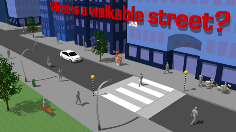
What makes a walkable street?
When deciding which factors make a street more or less walkable, a range of existing research was considered. Drawing upon this research, the key factors were combined into eight categories for the Walkonomics rating system:
Road safety: How safe do you feel from traffic on this street? It is influenced by actual road accident statistics (where available), street type, traffic speeds and activity.
Easy to cross: How easy it is to cross the street at regular points along the street? It is influenced by the traffic activity on the street, street width, physical barriers and provision of pedestrian crossings.
Pavements /Sidewalks: Are pavements/sidewalks provided along the street? Are they high quality? Are they wide enough? Do they have a lot of unnecessary clutter/furniture on them? Are they overcrowded?
Hilliness: Is the street flat or on a hill? How steep is any slope? If the street is steep, then are any hand-rails or seats provided?
Navigation: How easy is it to find your way around in this street and area? Is it easy to become lost here? Are any street names, pedestrian signs or maps provided?
Fear of crime: How safe do you feel from crime on this street? It is influenced by actual crime statistics (where available) as well as perceived fear or crime. Other factors include lighting, vandalism, graffiti and presence of police.
Smart and beautiful: How clean is the street? Is there much litter or vandalism? Is it regularly cleaned? Does the street have any trees or other green vegetation? Are the buildings attractive and in good condition?
Fun and relaxing: Is this a fun, interesting and popular place to be? Are there things to do in this street? Would you choose to spend time and hang-out here? Does the street have a relaxing atmosphere? Is it noisy or stressful? Can you play in this street?
What is the WalkoBot?
The WalkoBot is an automatic system that rates the walkability of streets by interpreting public datasets. Many of the streets in the UK and USA have been automatically rated by the WalkoBot using publically available data. Wherever possible the WalkoBot will use current data which is directly related to each rating category.
However in some cases (such as Pavements/Sidewalks) no relevant data exists and for these categories an average score (2.5 stars) is provided. It should always be remembered that the WalkoBot is an automated non-human system and will not get every rating correct. Walkonomics.com cannot guarantee that the WalkoBot rating data is totally free from any errors or inaccuracies.
Much effort is made to ensure that, wherever possible, ratings are based upon accurate data. If you don’t agree with the ratings provided by the WalkoBot you can always add your own rating which will affect the overall rating average. Once enough local users have added their ratings, any errors or inaccuracies should be cancelled out.
The Team
Adam Davies – Co-founder
Adam has over 15 years experience in Sustainable Transport and Retail Location Analysis, as well as a degree in Human Geography, a masters in Urban Sociology and training in Computer Science. Before founding Walkonomics he spent several years working in the UK, Europe and Africa with local communities, government and the private sector to create more walkable street environments. He has worked with the United Nations, Transport for London, Department for Transport, Commission for Architecture and the Built Environment and the Royal National Institute for the Blind. Adam has also contributed to various innovative pieces of research on ‘Shared Space’ streets, disabled peoples access, climate change and understanding the links between obesity and the built environment. You can follow him on Twitter.
Carsten Moeller – Co-founder
Carsten has over 20 years experience as a software engineer. Carsten created OSM2PO, a popular Java based software that converts OpenStreetMap data into a routable graph and is also a powerful and fast routing engine. OSM2PO has been downloaded over 3,500 times and is the software that powers Walkonomics global routing graph of over 150 million streets.
